volcanicity and intrusive land forms
Volcanic activity or volcanicity refers to the progress by which solid, liquid and gaseous are forced into the earth crust are ejected into the earth surface. Volcanicity give rise to very important features which are classified Intrusive and Extrusive.
Rocks below the crust have very high temperature but the great pressure exerted on them by the crust keeps roads in semi solid state for example molten or almost liquid state called magma always move where there is a crack or fissure. This is very common in the boundary of the plates.
Magma reach the crust and surface rough volcanoes which is a hole, vent or pipe in the earth crust through which magma escapes the surface during eruption. The magma may stay in the earth crust and hardens the resulting intrusive landforms or it may reach the surface either quietly or a great violence resulting to extrusive landforms.
If the magma contains a lot of gases especially steam then as the magma approaches the surface, the pressure on the gases is reduced. This causes the gases to expand rapidly which gives rise to violent explosion when magna reaches the surface. It loses it gases and it is called Lva. There are two types of lava which are
- Basic = fluid or watery – Low
- Acid = thick, very violent – higher
Intrusive features of volcanicity
These features include
- Sill
- Dike
- Laccoliths
- Batholiths
- Phacolith
- Lopolith
Sill
Sill is an intrusion of igneous rock which spreads along beddings in a nearly horizontal sheet. A sill may be up to 300 in thickness and several kilometers long
A sill is formed when a very fluid magma is forced between the bedding plane of magma that is concordant (agreement match) with the strata. The best known British example is the great within sill which runs across the pennies sills give rise to waterfall and aphides when they are crossed by rivers.
DIKE:
Dikes are long walls of rocks which lie across bedding plane. It is similar in size unlike a sill and extends for several kilometers. Dike lie discordantly with the strata they are formed when magma solidify across rock strata but do not reach the surface. Dike may be vertical or inclined and look like wall within the crust. When exposed to denudation, they may appear as upstanding walls or shallow trenches, depending on whether they are placed. Dike which are of less resistance may be eroded to form a depression like sill if found across a river bed, this sometimes give rise to waterfall of Hawick falls on river Ngemi in south Africa an example of a Dike is Cleveland dike in York shire in Britain.
Laccoliths:
This is a mass of igneous rocks intruded along the bedding planes of sedimentary rocks, like a sill but swelling out to form a dome sharp mass, the flat base being concordant with the strata into which it is intruded, the upper surface swelling but in a shape of a dome causing in over lying strata to each over it.
Sometimes the laccoliths is more complex with several masses one above the other exception through the hole looking like a cedar tree with spreading branches. Examples of laccoliths include El koub, Ou Djaut in Algeria and Henry Mountains in Ultata USA.
Phacolith:
A phacolith is the length straight ship of igneous rock formed when magma solidifies in folded sedimentary strata a distinction is sometimes made between phacolith and laccoliths. laccoliths has plastered up. Horizontal strata, phacolith occurs wither near the crest of an anticline or the base of a syncline in folded sedimentary strata and fed by conduit from beneath. A cordon hill is shropshire England is a phacolith exposed by erosion.
Lopolith:
This is a large intrusion of igneous rocks concordant with the strata but have the form of a saucer shape basin. It is formed when an injected magma in the bedding plane suddenly get depressed by an increase in weight above Busvelt lapolith in Transahel South Africa, Ryolite plateau, the yellow store neltronal parts in Nyomina USA.
Batholiths:
Batholiths are a large mass of dome shape igneous rock. This sometimes forms the heart or root of mountain and can extend for tens or even hundreds of kilometers across. A batholiths is formed when deep seated movement on an enormous scale so that the masses of magma cool slowly to form large crystalline rock like granite when exposed by prollon denulation, batholiths may form upland e.g. The Chaillu massive in Gabon and the Chinamora batholiths in North east Harare Zimbabwe which cover an approximate area of 16000m2.
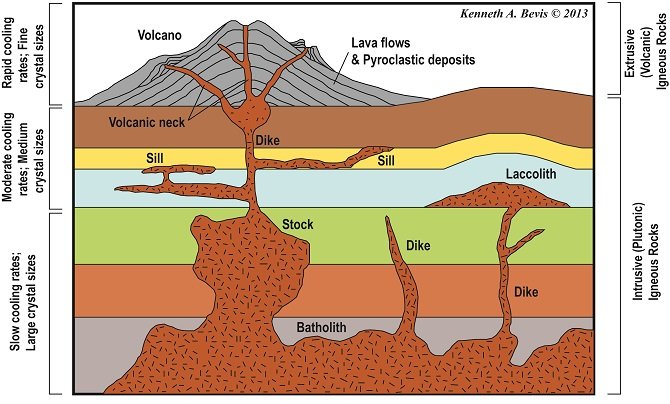
figure showing Batholith, dike, laccolith, sill

diagram showing Lopolith and Phacolith