Land forms produced by faulting.
Land forms produced by faulting
Faulting result in the deformation of landscape resulting to different features or landforms. The land forms include:
- Fault scarp or escarpment
- Block mountains or host
- Tilted blocks
- Rift valleys
- Faulted plateau
- Basins landscape
Fault scarp or escarpment:
A fault scarp or escarpment is a steep slope where the land falls from a higher to a lower level. It is caused by vertical movement along a fault. The are different types of fault scarp depending on their origin. The appearance of a fault scarp is modified by erosion, weathering and mass washing. In Bamenda the rock face sacculating Bamenda town and Bamenda up station is a fault scarp
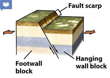
diagram of a fault scarp
Block mountains or Host
A block mountain or host is an upland bordered by fault on two or more side. Earth movement generate tensional force that turn to pull the crust apart and fault remain as it is or rises and the land on either side, subsides or drop down the upstanding block becomes the block mountain or host. The sides or edges are very steep and the summit is almost levelled e.g. the Vosges and black forest in Germany, Usambara mountains in North East of Tanzania.
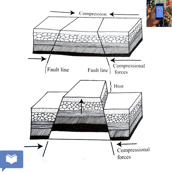
diagram of block mountains
Tilted blocks:
These are individual rock blocks which are also sharply defined like host but tilted. Tilted blocks often load so that one angle forms a higher peak while the surface of the block slopes more gently behind the higher peak. A tilted block has only one pronounced fault scarp. Examples include the Afar Triangle in Ethiopia, the Pennies in England, and the Sierra Nevada mountains of eastern California USA.

a tilted block
Rift valley:
A rift valley is also known as graben. It is a long depression or trough bounded by in facing fault scarp on both sides. The in facing scarp are steep and the floor of the rift valley is flat and elongated or long. It sometimes has steps on either side of the valley. A rift valley may be extended from a few kilometers to thousands of kilometers and it flow may contain a lake. The origin of rift valley is not yet fully understood. Several theories have been advanced. Most of them involving tensional and compressional forces related to large scale movement of the crust.
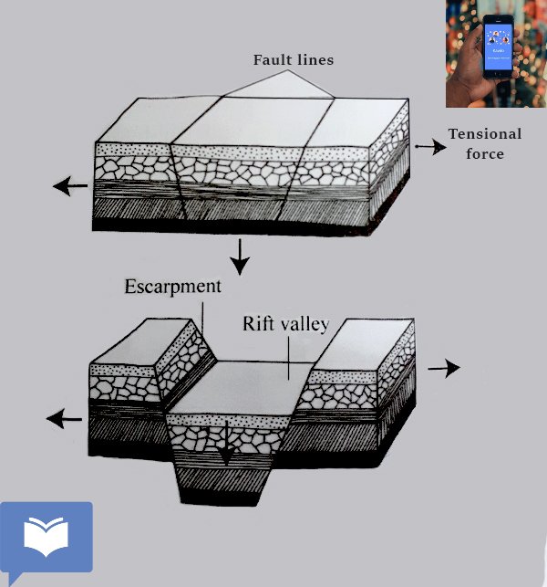
Rift valley formed by tensional forces
The tensional theory that holds that tension force operating in the earths crust may have pulled apart the two outer blocks, leaving the critical blocks to subside.

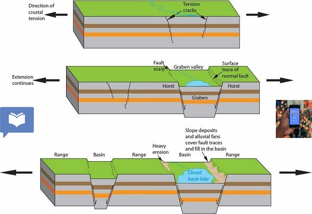
rift valley caused by compressional and tensional force
The bounding force are reversed but the trough edges may show minor normal fault due to subsequent collapse at the overhang. A good example of a rift valley is the East African rift valley that extend from Jordan in the middle east to Mozambique in south Africa passing through Ethiopia and red sea (7200km), this land form often occurs in an association with block mountains.
Faulted plateau and Basin landscape
This is the landscape made up of plateau and basin. It is from where a series of fault, some at right angles with others have affected an extensive landscape. In this case, blocks become down faulted to form basins while others are uplifted to produce step edge plateau. Example of this features are seen in area between the Rocky Mountains and the coast ridges in North America. Much of Africa is made up of this landscape e.g. Adamawa Plateau.
Download this article in pdf


MATOVU JOHN PAUL
November 25, 2023
Nice work
Jordres
November 23, 2025
School